It was the British who paved the way for the Nakba, the bloody founding of the state of Israel marked by the massacre and mass expulsion of hundreds of thousands of Palestinians from their homeland.
In A National Monument, which opens on Thursday at Dar el-Nimer for Arts and Culture in Beirut, a series of beautiful, hand-drawn maps made during the final years of British Mandate foreshadow the tragic events of 1948 and the decades of conflict to follow.
Visualising Palestine, a non-profit organisation established in 2012 to use data to draw attention to the Palestine-Israel conflict, has collaborated with Lebanese artist Marwan Rechmaoui to exhibit a series of two and three-dimensional maps of historical Palestine.
Inside the exhibition
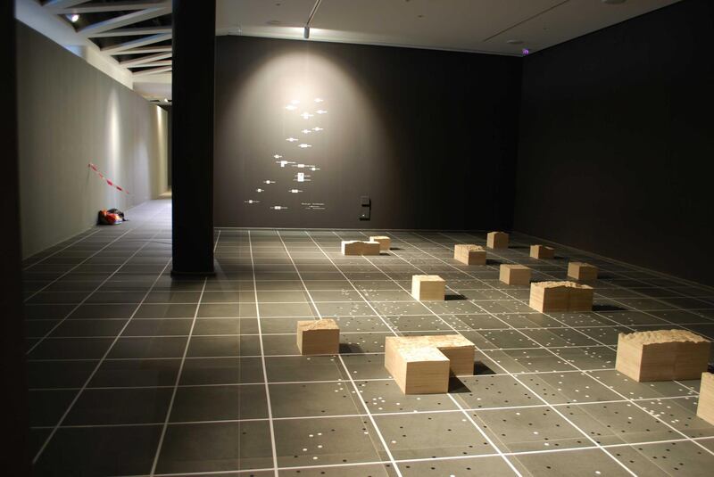
The highlight of the exhibition is a series of 22 carved plywood sculptures by Rechmaoui, each capturing a Palestinian city or town, sanded to a soft sheen. The detail and texture of these sculptures is a way of reclaiming the physicality of a land that has become almost mythical for many Palestinians in the 70 years since the Nakba. "For most of us my age and younger, Palestine is a story or it's an idea or it's a cause or it's a belief, but it's never an earth you stand on. You're not allowed to stand on it," says the artist, who was born in Lebanon in 1964.
Each sculpture is made up of squares of wood based on the grid overlaying a series of beautiful, hand-drawn maps created by the British between 1946 and 1948. Each sculpture is to scale with the maps, so while the smaller towns fit on a single square, Jerusalem covers four. Their positions in the gallery correspond to their geographic locations, creating a scale map of pre-Nakba Palestine that spans the length and breadth of the gallery.
The wooden sculptures are surrounded by a sea of 1,500 dots, representing smaller Palestinian villages from the period. The exhibition's curator, Ahmad Barclay, an architect, visual communicator, product designer and partner with Visualising Palestine, copied these from an overprint on the original maps created by the Israelis in the 1950s to show new settlements, as well as Palestinian villages marked as "destroyed" in Hebrew.
Visitors can walk between the sculptures, peering down at miniature tableaux of historical Palestine, a country that has taken on a symbolic status for many Palestinians living in exile, unable to return. While the maps are remnants of the colonial appropriation of Palestinian land, the sculptures are a tender ode to lost cities, a means of reclaiming what has been stolen.
The inspiration behind the work
“My father’s family is Palestinian. I was born here and I’m Lebanese, but I hear the Palestinian accent at home. It’s very close to me,” says Rechmaoui. “Growing up in a house where you have visitors sleeping on the couch for a few days and then disappearing and then another visitor sleeping on the couch for a few days and then disappearing. For me that’s the Palestinian issue. It’s transitional, always.”
He is fascinated by the symbolism of the grid, which he says represents the British imposition of modernity over Palestine. “It became a step towards colonising the country, but also introducing this way of thinking, which is alien from the local,” he explains. “When you have the grid, you can make the borders of a piece of land, of real estate. Before that, I still remember how my grandparents divided the inheritance of a piece of land. It was oral. It was like, ‘Your property is from this tree to that wall. And then from that wall to the other tree is your brother’s property.’ But if the speaker dies, nobody will know where the property is. So there was this conflict between the scientific approach of the grid and the poetic approach of the oral.”
What to expect
Barclay approached Rechmaoui to create the sculptures as a way of bringing to life a database of maps compiled by Visualising Palestine. Barclay was able to create computer-generated three-dimension models of the landscape by matching the historical maps to topographic information produced by Nasa. Online, the maps have also been geo-referenced to Google maps, so that visitors can contrast historical and contemporary views of the same city, town or region.
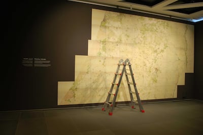
The collection, which includes Ottoman, French and English maps dating from 1870 to just before the Nakba, is available online at palopenmaps.org.
Visitors to the exhibition can explore these maps on digital tablets, comparing the historical maps to contemporary Google maps of the same cities and regions. The online database is designed to facilitate collaborations with organisations such as the Palestinian Oral History Archive, due to launch later this year. Barclay hopes that the maps will eventually be linked to photographs and stories from different areas of Palestine.
The curator has also chosen to exhibit prints of the maps that inspired the sculptures, which are beautiful drawings in shades of green, red and orange. “They’re aesthetically very attractive, almost like pieces of art,” Barclay says, “but also it’s this kind of artefact, evidence, from before the Nakba … There’s an element of these maps being an artefact of a process of colonisation. They’re created with the intent of mapping out the territory for the Zionist movement to purchase land, transfer land, to colonise the territory, initially hand-in-hand with the British.”
Learning about the topography of Palestine
Rechmaoui's work as an artist has long betrayed a fascination with space, geography and mapping, from his 2004 work Beirut Caoutchouc, a large rubber floor-mat based on a map of Beirut according to sectarian divisions, to his 2016 work Blazon, an enormous installation made up of 400 flags and 59 shields, conveying the written and oral histories of Beirut's districts as expressed through names, landmarks and figures.
In A National Monument, he has found a way to use the tools by which the British divided and appropriated Palestine – employing maps and grids to divide it up mathematically, as though it was an abstract concept, rather than a physical land, home to thousands of people – to reclaim Palestine as a tactile reality, both on a personal and a public level.
"I'm learning a lot about the topography of Palestine, but by hand, not by eye. I have to touch it all the time, see where the hard parts are, to sand them and make them softer, so I spend my whole day like a blind person going around the topography of the country," he says. "You start feeling the difference between coastal cities and mountainous cities. It's like Braille. And symbolically it's very much like that, because it's a place that you don't see, but you're touching it."
A National Monument is on show at Dar el-Nimer in Beirut until January 26
___________________
Read more:
The Palestinian artists giving new life to the streets of Beit Sahour
How one Palestinian fashion designer gives new life to old clothes
The Palestinian women refugees using Arabian motifs and poetry to create art
___________________


